General News
1 May, 2025
DId you feel the earth move last week?
A minor earthquake was recorded in the Gilgandra shire last week, around 23 kilometres east of Gilgandra.
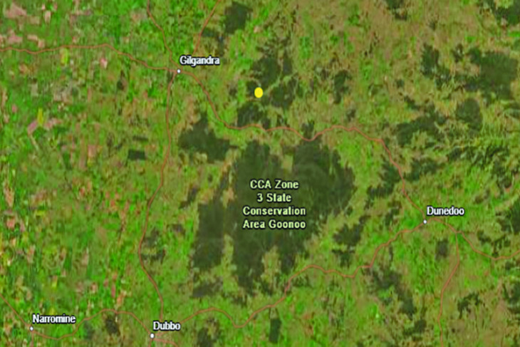
The Australian Government Geoscience Australia (AGGA) website recorded a 2.7 magnitude earthquake, with an epicentral time of 1.30am on Thursday, April 24.
The 2.7 magnitude earthquake was recorded by seismic instruments based in Dubbo, Cobar, Lightning Ridge, Tamworth, Young, and Oakdale in south-western Sydney.
The epicenter was in a heavily timbered area north of the Castlereagh Highway towards Mendooran, close to the Boyben State Forest.
That epicenter is roughly half-way between Gilgandra and Mendooran as the crow flies.
The origins of the Gilgandra shire earthquake began the day before at around 3.30pm before reaching the surface 10 hours later in the early hours of last Thursday.
The official latitude (-31.76) and longitude (148.90) were recorded on the AGGA website along with the depth (10 kilometres).
Another earthquake in regional NSW was recorded by the AGGA just three days later.
Around five kilometres south-west of Boorowa near the Cunningar Road, a 2.9 magnitude earthquake was recorded at 2.44am yesterday morning (Monday, April 28).
Boorowa is approximately 111 kilometres north of Canberra on the Lachlan Valley Way.
Seismic instruments all across southern NSW and even Victoria recorded the earthquake near Boorowa.
Another earthquake was felt south-west of Singleton last week.
That April 23 earthquake registered at 4.6 on the Richter scale.
Brittanica describes an earthquake as: “Any sudden shaking of the ground caused by the passage of seismic waves through Earth’s rocks. Seismic waves are produced when some form of energy stored in Earth’s crust is suddenly released, usually when masses of rock straining against one another suddenly fracture and ‘slip.’ Earthquakes occur most often along geologic faults, narrow zones where rock masses move in relation to one another.”
The AGGA website classifies earthquakes in eight categories, anything less than a magnitude of three, followed by magnitude three-3.9, then working up by one each classification (i.e, 4-4.9, 5-5.9, 6-6.9, 7-7.9, 8-8.9 and nine plus).
Using that scale, the Gilgandra and Boorowa earthquakes both fell in the lowest category, while the Singleton quake was in the third-lowest category of eight.
According to seismologists, most people won’t feel an earthquake under 3.5 magnitude on the Richter scale.